Commercial Space Supply
Overview of Commercial Space Supply and Readiness for Marketing
The supply of commercial space refers to undeveloped, commercially usable land that is legally designated in land-use plans (F-Plan) or zoning plans (B-Plan). This includes:
- Commercial (G) and mixed-use (M) development areas in the land-use plan (F-Plan), as well as commercial zones (GE) and
- restricted commercial zones (GE-e),
- industrial zones (GI),
- restricted industrial zones (GI-e),
- mixed-use zones (MI),
- core area (MK), or
- Special zone (SO) for various designated uses: large-scale retail, hotel/sports/recreation, science/research, medical university, or airport expansion) as defined by the BauNVO.
To obtain a building permit, a legally binding B-Plan (typically derived from the F-Plan) and existing infrastructure are required. When there is already a concrete interest in a specific use, amendments to the F-Plan and the drafting of a B-Plan are often carried out in a parallel process.
On the other hand, in some cases, although resolutions to draw up a B-Plan are passed, the process is then not pursued further—often for years—because, for example, a prospective user has postponed his or her project. The time required to make B-Plan and F-Plan sites available can therefore vary significantly depending on the individual case.
In addition to the legal validity of the zoning plan, factors such as the status of infrastructure development and the municipality’s access to the land through municipal ownership or a municipal project development initiative are decisive for the readiness for marketing or availability of the sites.
In the following, the supply of space is divided into four categories based on its availability ( Fig. 7; Table 2):
- Zoning Plan, immediately marketable: Sites with a legally binding zoning plan, existing infrastructure, and public ownership. In total, 75 ha of commercial land in the Hanover region will be classified as immediately marketable in 2025. This figure has thus risen significantly compared to 2024 (55 ha).
- Zoning Plan, Marketable Later: Sites with a legally binding zoning plan that are not yet developed and/or not publicly owned. At 143 ha, this land area has decreased slightly compared to the previous year (150 ha).
- Land-Use Plan (F-Plan): Sites for which a land-use plan designation exists but no legally binding development plan is yet in place, and for which, as a rule, no infrastructure is available. Here, the municipality documents its fundamental planning objective within the framework of preparatory urban land-use planning. However, it remains to be seen whether and when these areas will actually be granted building rights through binding urban land-use planning (legally binding urban land-use plan, development infrastructure). The majority of these areas are privately owned. The total area of F-Plan sites has increased slightly to 463 ha compared to the previous year (446 ha).
- Potentially reusable commercial brownfields: Due to generally significant usage restrictions (e.g., obsolete buildings that can no longer be used, contaminated sites, urban land-use plans that are no longer adequate), these areas have the lowest market readiness. At 82 ha, the volume of brownfields is slightly below that of the previous year (86 ha).
- Currently, municipalities are discussing prospective sites (intended new designations of commercial areas without a finalized zoning plan or development plan) totaling approximately 483 ha. According to inquiries made with the municipalities, approximately 10 ha of these prospective sites could be converted to building rights in the short term, and 119 ha in the medium term.
The following chart illustrates the trend in the total supply of commercial space—including potentially reusable commercial brownfields—starting in 2016. Over the past ten years, the supply has declined by 20% (Fig. 7).
When considering the total supply, it is important to note that potential land areas without a legally binding zoning plan are subject to significant reduction as planning details are finalized—including land set aside for development and public green spaces.
Table 2 shows the distribution of the current supply of commercial land across the respective municipalities:
- Larger areas of immediately marketable land with approved development plans (> 5.0 ha) are currently available in Barsinghausen (20 ha), the state capital of Hanover (19 ha), Garbsen (11 ha), and Uetze (11%).
- Land reserves with legally binding development plans (available either immediately or at a later date) of over 10 ha are located in Uetze (39 ha), the state capital of Hanover (26 ha), Pattensen (24 ha), Springe (21 ha), Barsinghausen (20 ha), Burgwedel (16 ha), Garbsen (15 ha), Lehrte (12 ha), Burgdorf (12%), and Sehnde (11 ha).
- F-Plan reserves (without a legally binding B-Plan) of over 20 ha are located in Lehrte (115 ha), Barsinghausen (71 ha), Uetze (53 ha), Springe (45 ha), Neustadt (41 ha), Sehnde (37 ha), and Garbsen (29 ha).
When comparing the development of potential commercial land supply to the previous year, it becomes apparent that two municipalities recorded a significant increase (> +2 ha) in potential land supply.
- Barsinghausen: With an increase in land potential of 32.2 ha, Barsinghausen has recorded by far the most significant gains in land area in this category.
- State Capital Hanover: The available land area in the state capital has increased by 7.0 ha. This was achieved through various new registrations, mostly of smaller individual plots.
- Neustadt: With an increase of 5.5 ha, Neustadt ranks third among the municipalities in this group. This is due to the expansion of the F-Plan area.
Potentially Reusable Brownfield Sites
Not only in metropolitan areas such as the Hanover region are the development opportunities for new “greenfield” commercial sites increasingly reaching their limits due to competition for land and requirements for the protection of open space. Therefore, the revitalization of brownfield sites, the careful management of land resources, and the redensification of use in existing commercial zones are among the central goals of municipal commercial land policy.
In this context, commercial brownfields are defined as sites formerly used for commercial purposes that are fundamentally suitable for commercial reuse but, due to significant barriers to use—such as contaminated sites, existing structures, or planning restrictions—cannot be mobilized through market mechanisms and thus necessitate public intervention. An indication of significant restrictions on use is a vacancy period longer than is customary in the market. A prerequisite for the need for public intervention is also that the property be of a significant size.
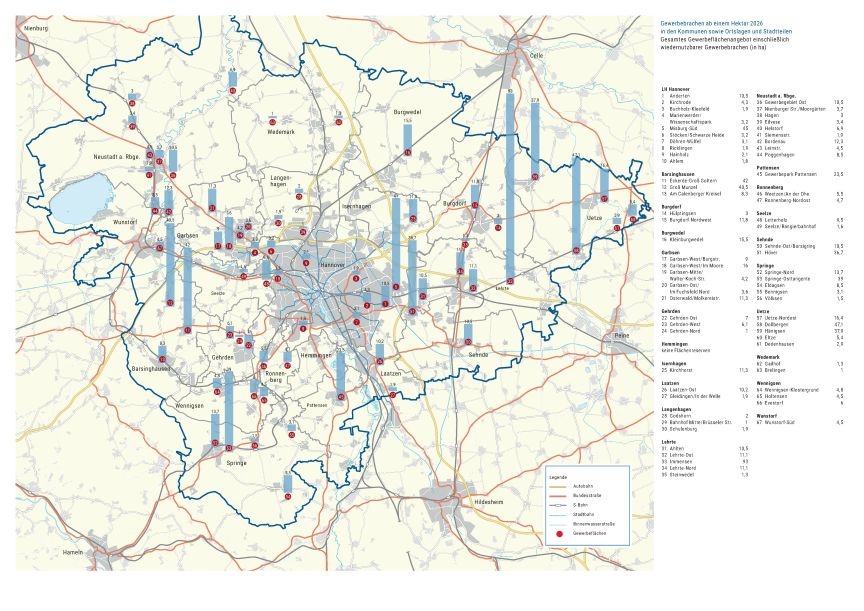
As part of the commercial land monitoring program, 13 properties totaling 82 ha are recorded in accordance with this definition; these are listed in the following table, sorted alphabetically by the surrounding municipalities and the state capital, Hanover (Table 3).
Available Space in the Hanover Region